This map is dated 1938 and has been enlarged in two sections to identify the particular lots.

Some observations though, Cabbage Tree Creek was called Taighum Creek, and Henry St John Bridgeman owned huge parcels of land from Sandgate to Boondall.
Lots 78 of 71 acres , 79 of 72 acres and 80 on the eastern side of Bald Hills Road, which was generally tea-tree swamp. Then from Lots 45 following Taighgum Creek in at least 3 parcels of around 100 acres each in the area behind Nudgee College, known as College Green Estate.

Location of the landholdings
William John Loudon owned the land where Bunnings is on the western side of the railway line.
Lots 115, 20 22. Moving eastwards he then owned 119 acres at what is now Fitzgibbon, but would have been the old dump, and Lot 25 on the opposite side of the Telegraph Road division.
A rather large landowner.
The blocks along Telegraph Road, then through to Barbour Road were at that time all subdivided into average size of 20 acre parcels. Names included Buckley, Leary, Brown, McCallum, Simpson, Speedy, Norris Tegge Cribb. Those lands were all fairly swampy, and covered with tea-trees, and some lands were covered in radiata pine trees, before modern engineering methods allowed their development.
To the eastern side of Lot 25, David Loughlin Brown and William Brown owned lot 93. Their property became the eastern boundary as shown in the red markings.
The next landholdings can be identified in relation to the Bald Hills Cemetery, now on Barrett Street.


Here the landholders from the Western side are Lot 95 W C Whitehill, A Norris J Barbour HW Barbour with a huge 143 acres. There was a roadway between their holding and Lot 97 owned by J. Grant with 105 acres then Lot 96 owned by J. Ferguson, with 77 acres which is opposite the Cemetery and Lot 95 of 93 acres owned by J. McPherson.
Putting this into perspective in today's landmarks, J Mc Pherson owned the land from Denham Street north, in the area of Mc Pherson Park, then Ferguson owned the lands on the south side of Barrett Street, (Jude Street side), J.. Grant owned the area where the water tower was built, and then the Whitehills/Norris/Barbour/Barbour owned the lands back towards the current Bald Hills TAFE and Norris Road State School.
Looking towards the northern boundary of Bald Hills Road, and adjoining the Whitehill section was Lot 99, owned by J. McCallun and T McNaught.
The road which runs to the east of there lot appears to be best identified as Norris Road. Then Lot 100 was owned by G. A Hope, a parcel of 102 acres where the original Queensland Housing Commission was developed.
Following Bald Hills Road, W Davis owned 35 acres, and this then adjoined a road, which is probably Bracken Street, up to where the Gawain Road shops are sited.
Across the road was W.Wilson with 20 acres now St John Fisher College, and adjoining that, another 19 acres owned by G. A. Hope of 19 acres, and W. Wilson owned a total of 40 acres in the area between Bald Hills Road and Barrett Street, another area which Queensland Housing Commission built homes.
Where did they live?

Breaking the "dots" into areas, it is seen that in the area bounded by Quinlan Street and Denham Street there were 7 properties occupied.
Following along Telegraph Road, and running west from the designated Council Reserve, there were 10 residences to the road which is now known as Phillips Street (south) and then north of Phillip Street to Barrett Street (opposite the cemetery reserve) there were 16 residences.
This appears to the area favoured for pineapple growing, on a slope. One of those farms was owned by Thomas Carr, who grew potatoes as well as pineapples.
Then in the area following Bracken Street there were 9 occupants.
On the lands to the west of Norris Road there were 6 residences.
Along Bald Hills Road there were 2 residences.
Perhaps the general geographical constraints of the suburb, high hilly land, low flat land, tea tree swamps, determined the use by the farmers.
There were a lot of piggeries. One which was still in effect along Telegraph Road in the 1960's.
That makes approximately 40 residences.
**********************************************************************************
However, not one person was residing on the 20 acre parcels near the railway line, at the Telegraph Road junction, except for one dwelling, which no doubt was occupied by the lady who opened and closed the railway crossing gates every time a train came past.
So how then did the area, with approximately 40 dwellings, and around 12,000 acres, owned by a handful of people, end up becoming the suburb it is today?
*******************************************************************************
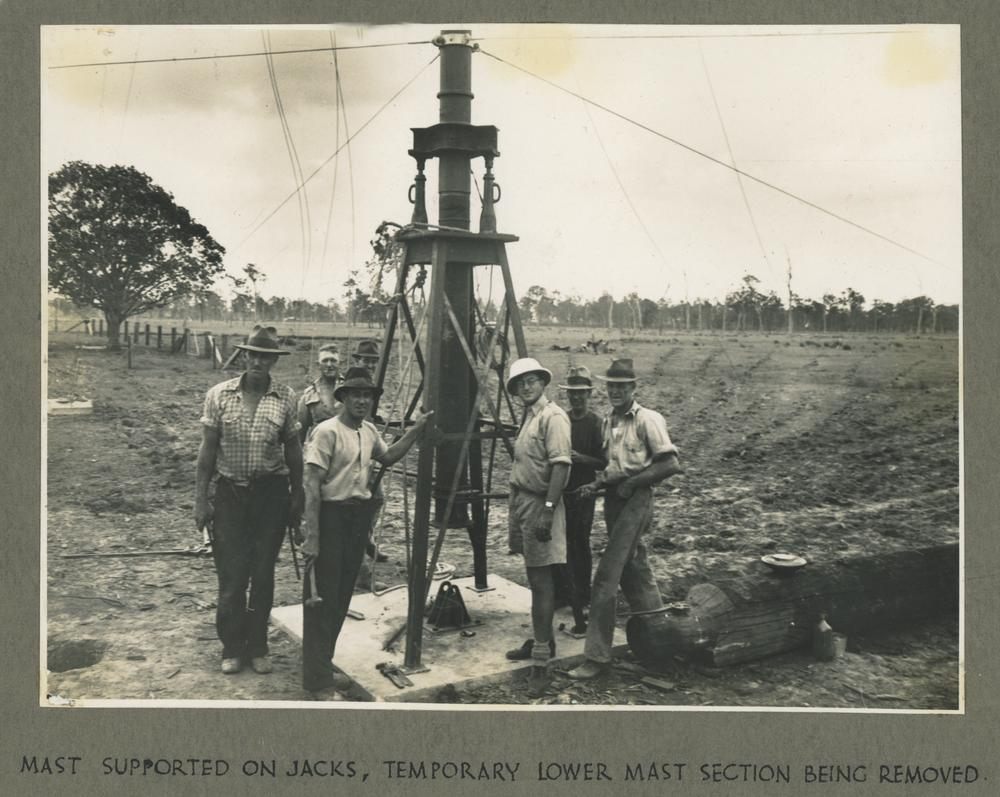

Construction of the Radio Mast on Cameron's land in Bald Hills

There were a few Bald Hills, in Australia, Yeppoon was originally called Bald
Hills,
and so was an area around Bathurst.
Guess this miner did okay for himself with the gold

This collection highlights some of maps in the Archives collections which show the development of Brisbane's Built environment.
The Town boundary for Brisbane was first declared in 1846. The 1858 map shows the town boundary area when Brisbane was proclaimed a Municipality in August 1859. The 1924 map shows the local authority boundaries that existed prior to the amalgamation of Greater Brisbane under one authority in 1925.
The hand-drawn and coloured 1864 map is particularly visually stunning and shows the full extent of boundary and western creeks on the inner western side of the Brisbane river. Western Creek was explored by John Oxley in 1823 as he searched for a suitable fresh water location for a new settlement.
In 1938 an aerial survey of the city was undertaken from which the then Town Planner, R McInnis, prepared a map showing current residential development in the City. Selected images from the 1938 survey are available from the City Archives
From 1925 Council tried to control the development of Brisbane through the introduction of a zoning scheme and later a Town Plan, the first of which was finally gazetted in 1965. This collection includes key town planning documents including early zoning maps and a 1951 land use survey taken across the city.
No comments:
Post a Comment